|
|
|
This page is just beginning--do you have anything to contribute to it? If so, tell
us!
Hiking
A Potomac Appalachian Trail Club Map #10 is incredibly helpful for planning hikes in the area;
you can purchase the map from Syria Mercantile, REI, Hudson Trail Outfitters, or from the PATC
website. (Note that the map was updated in 2008, but some vendors have the old 2003 edition.)
Here are some great hikes near camp:
-
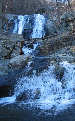 |
| Whiteoak Canyon Falls |
Getting to Whiteoak Canyon Falls is a pleasant, brief hike. To get to the trailhead,
take the Rapidan Road back to 670, but instead of turning right to go toward Criglersville,
turn left to go toward Syria. Turn right at the Syria Mercantile onto VA-643, and then left
on VA-600. After an extremely scenic drive, you’ll see a sign for parking for the Whiteoak
Canyon Trail. Like Old Rag—the #1 hike in the area—the parking lot fills on busy summer
weekends.
- Jones Mountain is a more strenuous hike, but has extremely rewarding views at the top
from Bear Church Rock. It starts from from the Rapidan Road, along the the Graves Mill
Trail—which until Hurricane Fran in 1997 was the road into Graves Mill.
- Hike to Big Meadows via Camp Hoover. There are two trails from Camp Hoover to
the Big Meadows facility along Skyline Drive; each trail is about 3 miles (plus the distance
from our cabins to Camp Hoover). The Mill Prong and the Laurel Prong Trails are each very
nice—try a round trip up one and down the other.
|